-
Share Glad these issues with Woodsdale road are being addressed. However, with no street parking, and with little to no visitor parking available at full condo complexes, where are Overnight visitors supposed to park their cars when visiting residents of Woodsdale road???
Making our local properties totally inhospitable to overnight guests directly affects aging residents' ability to stay socially connected, and to receive live-in support from family members or health aides etc. during times of crisis or illness, and also lowers our property values! What is the District thinking??? on Facebook
Share Glad these issues with Woodsdale road are being addressed. However, with no street parking, and with little to no visitor parking available at full condo complexes, where are Overnight visitors supposed to park their cars when visiting residents of Woodsdale road???
Making our local properties totally inhospitable to overnight guests directly affects aging residents' ability to stay socially connected, and to receive live-in support from family members or health aides etc. during times of crisis or illness, and also lowers our property values! What is the District thinking??? on X (formerly Twitter)
Share Glad these issues with Woodsdale road are being addressed. However, with no street parking, and with little to no visitor parking available at full condo complexes, where are Overnight visitors supposed to park their cars when visiting residents of Woodsdale road???
Making our local properties totally inhospitable to overnight guests directly affects aging residents' ability to stay socially connected, and to receive live-in support from family members or health aides etc. during times of crisis or illness, and also lowers our property values! What is the District thinking??? on Linkedin
Email Glad these issues with Woodsdale road are being addressed. However, with no street parking, and with little to no visitor parking available at full condo complexes, where are Overnight visitors supposed to park their cars when visiting residents of Woodsdale road???
Making our local properties totally inhospitable to overnight guests directly affects aging residents' ability to stay socially connected, and to receive live-in support from family members or health aides etc. during times of crisis or illness, and also lowers our property values! What is the District thinking??? link
Glad these issues with Woodsdale road are being addressed. However, with no street parking, and with little to no visitor parking available at full condo complexes, where are Overnight visitors supposed to park their cars when visiting residents of Woodsdale road???
Making our local properties totally inhospitable to overnight guests directly affects aging residents' ability to stay socially connected, and to receive live-in support from family members or health aides etc. during times of crisis or illness, and also lowers our property values! What is the District thinking???
Ellemess
asked
almost 3 years ago
Thank you for the question.
Developers and strata's are responsible to ensure that residents have adequate onsite parking and are not to rely on street or public parking. Public parking is available at Beasley Park when the park is open and at the tennis courts.
The work being completed is inline with the District's Mobility Master Plan - to create pedestrian and cycling connections between neighbourhoods, schools, recreation centres, trail heads, transit stops, and commercial centres.
-
Share Does this mean bikes will no longer be able to go up/ down Oyama Rd hill? That is the most dangerous. Where will people who live in the appartments, who park on the road, be able to park? on Facebook
Share Does this mean bikes will no longer be able to go up/ down Oyama Rd hill? That is the most dangerous. Where will people who live in the appartments, who park on the road, be able to park? on X (formerly Twitter)
Share Does this mean bikes will no longer be able to go up/ down Oyama Rd hill? That is the most dangerous. Where will people who live in the appartments, who park on the road, be able to park? on Linkedin
Email Does this mean bikes will no longer be able to go up/ down Oyama Rd hill? That is the most dangerous. Where will people who live in the appartments, who park on the road, be able to park? link
Does this mean bikes will no longer be able to go up/ down Oyama Rd hill? That is the most dangerous. Where will people who live in the appartments, who park on the road, be able to park?
Sandra
asked
almost 3 years ago
Thank you for the question. Bikers who choose to bike ride on Oyama Road will still be able to do so. Since street parking is no longer available vehicles will have to park in designated guest parking within the complex. Beasley Park is also an option when the park is open.
-
Share When soccer tournaments happen the parking lots overflow into Woodsdale. What’s the resolution there? on Facebook
Share When soccer tournaments happen the parking lots overflow into Woodsdale. What’s the resolution there? on X (formerly Twitter)
Share When soccer tournaments happen the parking lots overflow into Woodsdale. What’s the resolution there? on Linkedin
Email When soccer tournaments happen the parking lots overflow into Woodsdale. What’s the resolution there? link
When soccer tournaments happen the parking lots overflow into Woodsdale. What’s the resolution there?
Mathew Demelo
asked
almost 3 years ago
Thank you for the question.
When special events take place at the parks - organizers will need to arrange for overflow parking at separate locations. Arrangements will be made in advance of events.
-
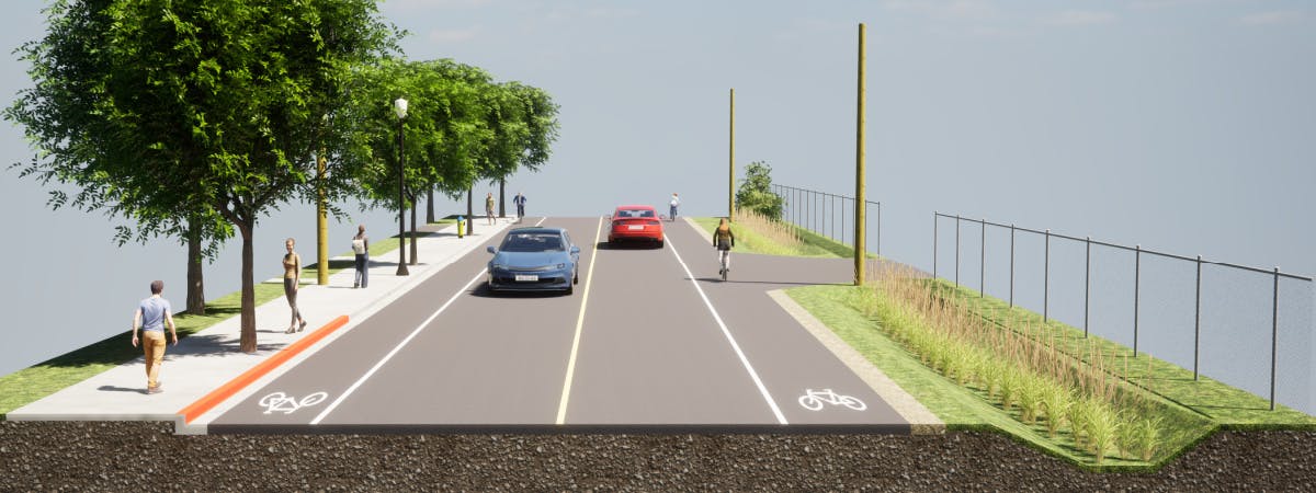
Share It's my understanding that near the RV Park and Marina, a bike-walking path will exist only on one side of the road. Is it possible in this "two-way traffic" section of the path to paint "dividing lines" similar to what exists on a road, in order to alert users to increase safety by treating it like a roadway with two-way traffic rules? Perhaps signage could also be provided to alert users to stay to the right and allow space for oncoming path users, and to exercise caution when "passing" slower users heading in the same direction? on Facebook
Share It's my understanding that near the RV Park and Marina, a bike-walking path will exist only on one side of the road. Is it possible in this "two-way traffic" section of the path to paint "dividing lines" similar to what exists on a road, in order to alert users to increase safety by treating it like a roadway with two-way traffic rules? Perhaps signage could also be provided to alert users to stay to the right and allow space for oncoming path users, and to exercise caution when "passing" slower users heading in the same direction? on X (formerly Twitter)
Share It's my understanding that near the RV Park and Marina, a bike-walking path will exist only on one side of the road. Is it possible in this "two-way traffic" section of the path to paint "dividing lines" similar to what exists on a road, in order to alert users to increase safety by treating it like a roadway with two-way traffic rules? Perhaps signage could also be provided to alert users to stay to the right and allow space for oncoming path users, and to exercise caution when "passing" slower users heading in the same direction? on Linkedin
Email It's my understanding that near the RV Park and Marina, a bike-walking path will exist only on one side of the road. Is it possible in this "two-way traffic" section of the path to paint "dividing lines" similar to what exists on a road, in order to alert users to increase safety by treating it like a roadway with two-way traffic rules? Perhaps signage could also be provided to alert users to stay to the right and allow space for oncoming path users, and to exercise caution when "passing" slower users heading in the same direction? link
It's my understanding that near the RV Park and Marina, a bike-walking path will exist only on one side of the road. Is it possible in this "two-way traffic" section of the path to paint "dividing lines" similar to what exists on a road, in order to alert users to increase safety by treating it like a roadway with two-way traffic rules? Perhaps signage could also be provided to alert users to stay to the right and allow space for oncoming path users, and to exercise caution when "passing" slower users heading in the same direction?
Sherry
asked
almost 3 years ago
Thank you for the question. Dividing lines are typically used to separate traffic. The design of the project was done in a way to ensure everyone's safety and will be closely monitored.
Signage can be a helpful tool, however when there is too much signage they tend to be ignored despite the well intended warnings. The City of Kelowna is going through a similar process of determining how best to address user courtesy along the Rail Trail and other pathways, and how best to monitor the areas. The issue is on staff’s radar and will need further discussion.
-
Share Will there be overnight parking at Beasley park and Reiswig parks to accommodate the guests of Emerald Point?
When there are soccer tournaments and there is a lot of overflow parking needed, where will the dozens of cars park when Woodsdale Road has no parking? on Facebook
Share Will there be overnight parking at Beasley park and Reiswig parks to accommodate the guests of Emerald Point?
When there are soccer tournaments and there is a lot of overflow parking needed, where will the dozens of cars park when Woodsdale Road has no parking? on X (formerly Twitter)
Share Will there be overnight parking at Beasley park and Reiswig parks to accommodate the guests of Emerald Point?
When there are soccer tournaments and there is a lot of overflow parking needed, where will the dozens of cars park when Woodsdale Road has no parking? on Linkedin
Email Will there be overnight parking at Beasley park and Reiswig parks to accommodate the guests of Emerald Point?
When there are soccer tournaments and there is a lot of overflow parking needed, where will the dozens of cars park when Woodsdale Road has no parking? link
Will there be overnight parking at Beasley park and Reiswig parks to accommodate the guests of Emerald Point?
When there are soccer tournaments and there is a lot of overflow parking needed, where will the dozens of cars park when Woodsdale Road has no parking?
Pat
asked
almost 3 years ago
Thank you for the question.
There will be no additional parking to accommodate residents and/or guest along Woodsdale Road.
Parking is permitted in park lots, however park gates are locked between 11pm and 6am and parking is not permitted overnight. Park Bylaw - Section 2.10
Residents and guests are encouraged to park at Emerald Point or whichever strata complex they live in or are visiting.
-
Share I share concerns expressed about the Bottom Wood Lake Rd and Woodsdale Rd intersection. I live in this neighbourhood, and my neighbours and I have experienced many issues and dangers due to heavy traffic, especially at particular times of the day/week, during the tourist season, and when games and events are being held in the nearby parks and surrounding area. Further, current and planned construction in the area will increase density and traffic. Will the traffic counts take such factors into consideration? Could traffic lights be considered? on Facebook
Share I share concerns expressed about the Bottom Wood Lake Rd and Woodsdale Rd intersection. I live in this neighbourhood, and my neighbours and I have experienced many issues and dangers due to heavy traffic, especially at particular times of the day/week, during the tourist season, and when games and events are being held in the nearby parks and surrounding area. Further, current and planned construction in the area will increase density and traffic. Will the traffic counts take such factors into consideration? Could traffic lights be considered? on X (formerly Twitter)
Share I share concerns expressed about the Bottom Wood Lake Rd and Woodsdale Rd intersection. I live in this neighbourhood, and my neighbours and I have experienced many issues and dangers due to heavy traffic, especially at particular times of the day/week, during the tourist season, and when games and events are being held in the nearby parks and surrounding area. Further, current and planned construction in the area will increase density and traffic. Will the traffic counts take such factors into consideration? Could traffic lights be considered? on Linkedin
Email I share concerns expressed about the Bottom Wood Lake Rd and Woodsdale Rd intersection. I live in this neighbourhood, and my neighbours and I have experienced many issues and dangers due to heavy traffic, especially at particular times of the day/week, during the tourist season, and when games and events are being held in the nearby parks and surrounding area. Further, current and planned construction in the area will increase density and traffic. Will the traffic counts take such factors into consideration? Could traffic lights be considered? link
I share concerns expressed about the Bottom Wood Lake Rd and Woodsdale Rd intersection. I live in this neighbourhood, and my neighbours and I have experienced many issues and dangers due to heavy traffic, especially at particular times of the day/week, during the tourist season, and when games and events are being held in the nearby parks and surrounding area. Further, current and planned construction in the area will increase density and traffic. Will the traffic counts take such factors into consideration? Could traffic lights be considered?
Sherry
asked
almost 3 years ago
Thank you for the question. The District does monitor the traffic within the District as part of an annual traffic data collection program, this intersection will be monitored as part of that program. Various traffic control mechanisms such as traffic lights will be considered as traffic data for the area is collected and analyzed.
-
Share I share the concern regarding the elimination of street parking on Woodsdale. While some of those who currently park on Woodsdale are local residents who perhaps can/should park in designated and visitor parking in their complexes, many are not. Often Woodsdale (and nearby sidestreets such as the one on which I live) is used for "overflow" parking by those visiting local businesses and parks during busy times. As the area grows and densifies, we can anticipate additional pressure on existing lots and sidestreets. Could overflow parking - and perhaps paid overnight parking - be offered on the land the District purchased across the street from Beasley? Also, will all proposed/new residential developments in the area be required to have more generous parking allotments for future residents and guests in order for the development plans to be approved? on Facebook
Share I share the concern regarding the elimination of street parking on Woodsdale. While some of those who currently park on Woodsdale are local residents who perhaps can/should park in designated and visitor parking in their complexes, many are not. Often Woodsdale (and nearby sidestreets such as the one on which I live) is used for "overflow" parking by those visiting local businesses and parks during busy times. As the area grows and densifies, we can anticipate additional pressure on existing lots and sidestreets. Could overflow parking - and perhaps paid overnight parking - be offered on the land the District purchased across the street from Beasley? Also, will all proposed/new residential developments in the area be required to have more generous parking allotments for future residents and guests in order for the development plans to be approved? on X (formerly Twitter)
Share I share the concern regarding the elimination of street parking on Woodsdale. While some of those who currently park on Woodsdale are local residents who perhaps can/should park in designated and visitor parking in their complexes, many are not. Often Woodsdale (and nearby sidestreets such as the one on which I live) is used for "overflow" parking by those visiting local businesses and parks during busy times. As the area grows and densifies, we can anticipate additional pressure on existing lots and sidestreets. Could overflow parking - and perhaps paid overnight parking - be offered on the land the District purchased across the street from Beasley? Also, will all proposed/new residential developments in the area be required to have more generous parking allotments for future residents and guests in order for the development plans to be approved? on Linkedin
Email I share the concern regarding the elimination of street parking on Woodsdale. While some of those who currently park on Woodsdale are local residents who perhaps can/should park in designated and visitor parking in their complexes, many are not. Often Woodsdale (and nearby sidestreets such as the one on which I live) is used for "overflow" parking by those visiting local businesses and parks during busy times. As the area grows and densifies, we can anticipate additional pressure on existing lots and sidestreets. Could overflow parking - and perhaps paid overnight parking - be offered on the land the District purchased across the street from Beasley? Also, will all proposed/new residential developments in the area be required to have more generous parking allotments for future residents and guests in order for the development plans to be approved? link
I share the concern regarding the elimination of street parking on Woodsdale. While some of those who currently park on Woodsdale are local residents who perhaps can/should park in designated and visitor parking in their complexes, many are not. Often Woodsdale (and nearby sidestreets such as the one on which I live) is used for "overflow" parking by those visiting local businesses and parks during busy times. As the area grows and densifies, we can anticipate additional pressure on existing lots and sidestreets. Could overflow parking - and perhaps paid overnight parking - be offered on the land the District purchased across the street from Beasley? Also, will all proposed/new residential developments in the area be required to have more generous parking allotments for future residents and guests in order for the development plans to be approved?
Sherry
asked
almost 3 years ago
Thank you for the questions. Signage on side streets indicating “local residents parking only” will be considered at the completion of the project if issues are observed. Properties newly acquired by the District, across the street from Beasley are zoned ALR (Agriculture Land Reserve) parking cannot be the sole use of ALR property. Any commercial or residential development must provide a proposed parking plan that meets the required parking outlined in the Zoning Bylaw. If a developer proposes a plan for on-site vehicle parking that does not meet the District’s parking regulations, Council has the authority to approve or deny the proposed project. Council considers existing policy documents, including the Official Community Plan (OCP) and Mobility Master Plan, when evaluating development proposals in general, in proposed vehicle parking plans in particular.
-
Share With increased bike and vehicle traffic on Woodsdale Road comes increased traffic on the sidestreets, several of which are "dead ends" that often confuse non-local cyclists and drivers, and are very difficult for larger vehicles to turn around on in order to exit. Could more prominent, better placed and additional signage be provided on these streets to better indicate No Through Road, Local Traffic Only, and/or where vehicles can safely turn around to exit? Thank you. on Facebook
Share With increased bike and vehicle traffic on Woodsdale Road comes increased traffic on the sidestreets, several of which are "dead ends" that often confuse non-local cyclists and drivers, and are very difficult for larger vehicles to turn around on in order to exit. Could more prominent, better placed and additional signage be provided on these streets to better indicate No Through Road, Local Traffic Only, and/or where vehicles can safely turn around to exit? Thank you. on X (formerly Twitter)
Share With increased bike and vehicle traffic on Woodsdale Road comes increased traffic on the sidestreets, several of which are "dead ends" that often confuse non-local cyclists and drivers, and are very difficult for larger vehicles to turn around on in order to exit. Could more prominent, better placed and additional signage be provided on these streets to better indicate No Through Road, Local Traffic Only, and/or where vehicles can safely turn around to exit? Thank you. on Linkedin
Email With increased bike and vehicle traffic on Woodsdale Road comes increased traffic on the sidestreets, several of which are "dead ends" that often confuse non-local cyclists and drivers, and are very difficult for larger vehicles to turn around on in order to exit. Could more prominent, better placed and additional signage be provided on these streets to better indicate No Through Road, Local Traffic Only, and/or where vehicles can safely turn around to exit? Thank you. link
With increased bike and vehicle traffic on Woodsdale Road comes increased traffic on the sidestreets, several of which are "dead ends" that often confuse non-local cyclists and drivers, and are very difficult for larger vehicles to turn around on in order to exit. Could more prominent, better placed and additional signage be provided on these streets to better indicate No Through Road, Local Traffic Only, and/or where vehicles can safely turn around to exit? Thank you.
Sherry
asked
almost 3 years ago
Thank you for the questions and comments. Once the project is completed staff will do an assessment of signage in the area and determine if additional signage is required. No Through Road signs are certainly appropriate, if they are not already placed.
-
Share Is there any plan for a round-about at the intersection of Bottom Wood Lake Road and Woodsdale? It is very difficult to turn left onto Woodsdale during the summer when Beasley is busy. on Facebook
Share Is there any plan for a round-about at the intersection of Bottom Wood Lake Road and Woodsdale? It is very difficult to turn left onto Woodsdale during the summer when Beasley is busy. on X (formerly Twitter)
Share Is there any plan for a round-about at the intersection of Bottom Wood Lake Road and Woodsdale? It is very difficult to turn left onto Woodsdale during the summer when Beasley is busy. on Linkedin
Email Is there any plan for a round-about at the intersection of Bottom Wood Lake Road and Woodsdale? It is very difficult to turn left onto Woodsdale during the summer when Beasley is busy. link
Is there any plan for a round-about at the intersection of Bottom Wood Lake Road and Woodsdale? It is very difficult to turn left onto Woodsdale during the summer when Beasley is busy.
Martha
asked
about 3 years ago
Thank you for the question.
Long term planning has not identified the requirement for a roundabout at the intersection. Construction of a four-way stop is problematic as it would trigger upgrades to accommodate truck traffic. As safety is the District’s primary concern, staff are currently reviewing traffic counts at the intersection, and will soon determine next steps.
-
Share I live on Woodsdale Road I am wondering if you are putting culverts down when the ditches are fill in. Thank You on Facebook
Share I live on Woodsdale Road I am wondering if you are putting culverts down when the ditches are fill in. Thank You on X (formerly Twitter)
Share I live on Woodsdale Road I am wondering if you are putting culverts down when the ditches are fill in. Thank You on Linkedin
Email I live on Woodsdale Road I am wondering if you are putting culverts down when the ditches are fill in. Thank You link
I live on Woodsdale Road I am wondering if you are putting culverts down when the ditches are fill in. Thank You
Joy
asked
almost 3 years ago
Thank you for the question.
The majority of the ditches will remain open after construction. There will be some smaller sections that will require infill. Any section that has infill will also have drainage to accommodate water being collected into the system.